The Spectacular Road from Leymebamba to Cajamarca
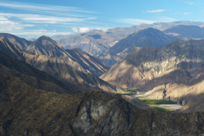
The road from Leymebamba to Cajamarca areas is via the most spectacular roads in Peru. Between the two cities is the deep (twice as deep as the Grand Canyon) Marañon Canyon. It is an unforgettable journey.
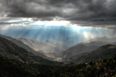
Leymebamba is at 2200m (7215ft) and the road climbs past the Mummy Museum up to a the lip of the Marañon Canyon at 3615m (11855ft). On a the best days you are here early and a sea of cloud obscures the valley bottom, yet you can see your road ahead some 5 hours driving time at the western side of the Canyon. The total descent to the crossing point is 2800m (9180ft) and you drive by high grassland, cloud forest and dry forest. You will need to be wrapped up warm at the top and ready to peel off layers as you descend. Just above Balsas on the way down is Hornopampa – Oven Plain – well named as here the heat really kicks in.
Balsas is the lowest point of the journey and is where a new bridge takes you across the Marañon. This is a great place for a leg stretch and to try the roasted in-their-shell peanuts. The drive on the western bank passes many different cacti as it winds up towards the Limon Plain. At Limon you can see the road zigzagging above to the western edge of the canyon – the best stopping point is before you get to the last hairpin.
Just beyond is the market town of Celendin which is famous for straw hats made and worn there. From there the road twists and turns, gently climbing to a flat pass. The last section from Encañada is particularly beautiful in the afternoon light. A little further and you get the first glimpse of Cajamarca spreading out in the valley below.
Lonely Planet used to say that travelling this road was for “die hards” only. It is still a long day, but the road condition has greatly improved and journey times and bumpiness reduced. Vilaya Tours offers the route as one of the ways of accessing or leaving the Chachapoyas area.
Return to Blog Articles